Titles do not show in the blog

Titles do not show in the blog
Mojave National Preserve

Sunday, October 23, 2022

Smokescreens and Smoke Signals


Smokescreens were originally clouds of smoke created to conceal military operations, but the term has come to mean a ruse designed to disguise real intentions.  I created a ruse to conceal my true intentions for this adventure by saying I was going to a place where nobody goes.  I assume that nobody believed that I could go where absolutely, including me, goes.  I closed my last blog post saying, “Maybe it’s an adventure of gross ignorance, outright lying, or of poetic definition.  I promise to tell you before it’s over.”  And now I will.  


I need adventure as much as many of you need poetry, art, friendships, and zoom meetings to pacify the pandemic.  On searching for a place to hike, explore, and generally escape society, a place I had not yet visited, not far from home, and for which I could find compelling information, I came up blank.  But what about a place for which little information is available, a place to explore like native Americans did thousands of years ago?

I put up a blog post saying I would go where nobody goes, and then started figuring out how I would do it.  After a month’s hard study, I settled on a town in central Utah, which is surrounded by public land that few people visit, and if they do, they miss what appears from maps and satellite imagery, inaccessible by normal means.   


I decided to teach myself how to go where nobody goes.  I needed a deadline to get me started.  So I reserved a room in Richfield, Utah, to use as base camp.  Then after a month’s hard study, I departed.  Where exactly was I going from base camp, was still an open question  I would figure it out when I get there.  The important thing was keeping a safe distance from crowds. I printed out directions for the carefully selected sites that I would visit, the ones that would serve my purpose.  I was hooked.   


After planning and packing, I was cautiously excited on the morning I left Pasadena for two days of driving the backroads northeasterly through a succession of charming small towns.

Having arrived in Richfield, I have stayed here every night here for the past two weeks.  I have hiked a high peak, scrambled to an old gold-rush settlement where the abandoned wagon roads are barely discernable, driven on rough roads in the desert in search of lava tubes and hot springs which were not where my maps said they were.

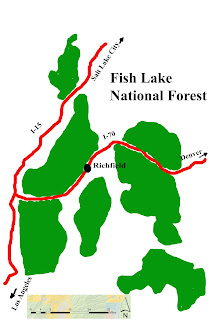
A lot of people live in Richfield and a lot more pass through it on I-70.  But the travelers do not come here as a destination.  Richfield in the largest town for over a hundred miles in any direction, and they use it as stopover on their long drives.  The local people serve the travelers with motels, gas stations and chain restaurants at the two freeway exits.     

Two Hours and Forty Miles Later

Unlike them, I came because of the Fish Lake National Forest, which flanks Richfield on two sides.  Maps of trails in the Forest are almost entirely wrong, by my experience, and if anyone wants to follow what I am doing here, I can give you what the forest service seems unable to provide, but only for the small portion of the Fish Lake that I visited.  In two weeks I have risen along a gradual arc from “know almost nothing at all” to “pretty thorough acquaintanceship.”   


 Main Street, Richfield, Utah

I suppose you are wondering how the above pictures relate to my story.  I have described the smokescreen of “where nobody goes,”  Now lets talk about smoke signals.  

While driving home to base camp in Richfield, I saw this plume of smoke rising vertically in the distance.  After forty miles and two hours of driving toward it, the plume had widened and its top was like the anvil-shape of a thundercloud.  Back in Richfield, it had widened and spread out considerably.  


 Little Wonder Café in Richfield

The next morning I went to the Little Wonder Café, a local place not easy for travelers to find, and sat with the old men who come there every morning.  They were talking about yesterday’s “control burn.”  We all agreed that the plume of smoke was too fierce-looking to be a control burn, which the forest service often does during conditions when fire will burn slowly.  But no rain had fallen in over a month; everything was very dry.  “There’s no such thing as a control burn,” one of them said.  


Two days after I first saw the plume of smoke

Two days later, smoke still hangs over the mountain.  A strong wind is pushing it.  I wonder what people near Santa Fe, NM, think about control burns as they look at the foundations of what used to be their homes.  Smoke signals are used to transmit news, signal danger, or to gather people to a common area.  They could often be seen from as far away as fifty miles.  This smoke signal made us wonder if a little diminished mental capacity was involved or if foresters have become so afraid of wildfires that they use control burns even in risky conditions. 


Richfield, Utah

 
some info about it:
Oct hi 68, low 32
Nov hi 52, low 23
Jan hi 41, low 16
the town is 2.5 miles long, north to south
Population 7,500,
Elevation 5,280’
only 5” of snow falls in January.


Richfield and the Fish Lake National Forest  


Friday, October 21, 2022

The Utah Underground


About two million years ago, Magma flowed on the surface of the western Utah desert.  It flowed again as recently as a few centuries ago, but this time along faults in the Basin and Range physiographic province.  I’d like to take you on an underground adventure for a feeling of what happened.  


To walk out safely on a lava flow is to carefully watch your step—black lava rocks are often loose and to fall on them is like falling on spikes.  Cracks like this one are common because as the molten rock flowed, its surface cooled first, becoming solid rock, which was pushed and dragged by the flow beneath like ice on a river.  


Sometimes the liquid rock flowed completely out from under the solid surface, leaving a cavern underneath.  Eventually, lopping lengths of the roof collapsed forming valleys, which over time eroded into a pasture-like floors with steep canyon walls.  


Walking on the surface where a cavern has not collapsed, we often see holes through which we can peer deep into the earth to the bottom of what was once a flowing mass of magma.  A hole like this one begs the question of how strong is the roof on which we stand.  It’s like asking, “How strong is the life that keeps me from the underground.”  


Climbing down into one of the caved-in sections, we see the entrance to a cave that might be interesting to explore.  It’s just a bridge, really, and we can see the other side.  In such manner, perhaps, Dante went into hell and came out to tell us what it’s like.  


A more mysterious and adventurous trip might be to enter where lava once flowed and from which we cannot see where it was going.  I saw many such entries along a trek following the edge and the bottom of this long ancient tube and thought that in one place I might go for an underground visit.   


Entering such a place is almost always a matter of climbing over boulders that broke from the collapsing roof, who knows how long ago.  I chose this entry because it looked easier than most of the others.  


Inside, the going is easy and the scenery interesting.  The roof looked stable as any human-made tunnel, and floor is like a garden path.  Ahead there is a light to guide our way, but we know its just one of the holes we saw earlier.  I hope you’re enjoying this underground stroll; we’ll be out of here soon and on to a completely different underground experience.  


There’s daylight ahead and maybe a way to climb out without having to go back to where we climbed in.  Did I mention that we’re in The Black Rock Desert, under it really, in the Tabernacle Hill area of Millard County?   


Driving a roly-poly road across a flat and arid desert we’re searching for hot water.  They said it’s out here, but hard to find.  They say that in volcanic areas water may come in contact with rock that has been heated by magma below, and we’re not far from the volcanic area of lava tubes.   


And there it is a pool of water in the desert—no creek flowing into it, no erosion around it, just a container of water alone, or is it?  


We’ll have to investigate this strange feature; unlike anything I’ve seen.  A playa lake comes to mind, but it’s not shallow and wide like a playa, and no rain has fallen for weeks; playas are usually dry except after rain.   


It has a shallow end and a deep end—strange.  The water has no obvious current to tell where it comes from, no higher water line to show where it might have risen to.  We’ll have to investigate.  


The shallow end is fine for wading up to our knees.  Warm, but not hot.  So clear is the water that I can’t wait to explore the deep end.  


Peering down into the deep, I cannot see the bottom.  It’s about ten feet down to where it becomes too dark to see.  Formations along the bank appear to be deposits from water, so the water must be rich in minerals.  Since there is no inflow from the surrounding surface, it must be coming from deep underground.  Don’t worry, we’ll not be going down under as we did in the lava.  No scuba diving for us.   


Fish live here!  So the water must not come and go; it must be here all the time.  These fish are about six inches long, so they’re not one of tiny species that can survive a dry pond as found in Death Valley and the Wind River Mountains of Wyoming.  


The air is still and the water so reflective that a scene along its edge is like a range of mountains.   


And so I leave you for now, perhaps still wondering after my many hints, where nobody goes and where I am.  Maybe it’s an adventure of gross ignorance, outright lying, or of poetic definition.  I promise to tell you before it’s over.   

Tuesday, October 11, 2022

Where People Used to Love


aspen trees

where nobody goes

flaunt their yellow tops

 as if it matters

to elk and bears   


their leaves change color

like faded pages

of an ancient book

beginnings and ends

nobody sees anymore   


in a valley between fingers

of forgotten forest

a small town hosts a wanderer

back from hiking to 11,000 feet

loving the joy and pain      


cold air stings the climb

on slopes of Delano Peak

clouds sprinkle snow like salt

on those who used to come

for what, I try to guess      


maybe they got older

trudging slower

resting more

dealing with change

observing small things    


jeeps and cars can go downhill

but can they go back up?

and gas is two dollars cheaper

than where most of you live   

Friday, October 7, 2022

On the Way to Where Nobody Goes


There is more space where nobody is than where anybody is.


Here I am this hot evening in Mesquite, Nevada, which provides you with the general direction of my mysterious destination, as if you care. This whole idea of “where nobody goes” is likely ridiculous to you, and to me as well.  It is becoming a revelation to learn that if I look carefully, I can find the most wonderful ways to waste time.   


My trips give a look at aspects of nature I would never have had in any other way.  They also give me a look into my own brain. 


At home I read a lot.  It keeps me from feeling ignorant and feeling smart—both mistakes.  My questions during discussions are based on assumptions that boxed my listeners in.  When in wilderness I know only what a visitor gleans.  I am as ignorant of its culture as a traveler to Mexico City.  To listen, to observe, to hope for some small interaction, a bit of inspiration—far from knowing or becoming able to describe it—that is what counts.